by Carl Islam, LLM (Exon)(International Business Legal Studies), Diploma in Art Law (Institute of Art & Law) (London), Barrister & CMC Registered Mediator – Contentious Probate & Cultural Heritage Disputes – 1 EC Barristers, Temple, London.
AI – ‘In antiquity, it was deeply believed that gods, nymphs, and divine spirits inhabited the trees, forests, and sacred groves of Corfu (then known as Corcyra or Korkyra). [1]
Like the rest of the ancient Greek world, the inhabitants of Corfu practiced a religion where the natural environment was inextricably linked to the divine. Nature was not seen merely as resources or scenery, but as a living domain populated by deities and mythological beings. [1, 2, 3]
The Sacred Groves (Alse) of Ancient GreeceIn ancient Greek religion, a sacred grove (called an alsos) was a protected pocket of woodland dedicated entirely to a specific deity. [1, 2]
The Dwelling of Spirits: Trees were believed to be the physical anchors or homes of semi-divine beings called Dryads and Hamadryads—nymphs whose lives were bound directly to the lifespan of their specific tree. [1, 2]
Inviolable Spaces: Damaging or cutting down a tree in a sacred grove without performing an exploratory ritual or offering sacrifice was considered a severe act of sacrilege, often thought to invite madness or death from the gods. [1, 2]
Corfu’s Divine Connection to NatureCorfu held a highly prestigious place in ancient myth and religion, and its lush geography was tied directly to the gods:
The Legacy of Nymphs: The island itself was named after Korkyra, a beautiful water nymph (naiad). According to myth, the sea god Poseidon fell in love with her and abducted her to this untouched, lush paradise. The island’s vibrant greenery and abundant fresh springs were viewed by ancients as the literal footprint of this divine union. [1, 2, 3]
The Cult of Artemis: Corfu was home to a major sanctuary dedicated to Artemis, the goddess of the wilderness, forests, and wild animals. The famous 6th-century BCE Doric Temple of Artemis on Corfu featured a massive stone pediment depicting Medusa as Potnia Theron (“Mistress of Animals”). Shrines to Artemis were almost universally situated within or adjacent to wild, heavily wooded areas, where her presence could be felt among the trees. [1, 2, 3]
Apollo and Poseidon: Major temples to Apollo (god of light and order, often associated with laurel groves) and Poseidon also existed on the island. Ancient tracking of these sanctuaries shows that they heavily incorporated natural landscape elements like dedicated plots of trees (temene) and freshwater springs to bridge the human and cosmic realms. [1, 2]
Homer’s Divine Gardens: In Homer’s Odyssey, Corfu is widely identified as Scheria, the mythical island of the Phaeacians. Homer specifically describes the magical, ever-blooming orchards and sacred groves of King Alcinous, which were blessed with perpetual fruit and watered by springs directly gifted by the gods. [1, 2, 3]
While the vast olive groves that cover Corfu today were largely planted much later during the Venetian rule, the ancient Corfiots walked through a landscape of oak, cypress, wild olive, and pine trees, treating many of those woodlands as literal, physical temples where the gods walked among mortals. [1, 2, 3]
Artists of the Ionian School (also known as the Septinsular or Heptanesian School of Art) portrayed the classical and mythological divinity of Corfu’s nature not by painting literal figures of gods, but by romanticising and idealising the landscape to evoke an atmospheric, sacred, and mythological presence.
Influenced deeply by Western European movements, Italian Baroque, and the concept of an idyllic Arcadia, they transformed the island’s unique topography into a space where the divine felt inherently woven into the environment. [1, 2]
They achieved this through several specific artistic techniques and thematic framing:
Mythological Transfiguration of Topography: Rather than capturing raw, unmanipulated nature, painters deliberately framed specific locations on Corfu to evoke classical lore. For example, the dramatic cliffs of Palaiokastritsa and the coastal waters were painted to deliberately mirror Homer’s Odyssey, casting Corfu as the mythical island of Scheria (the Kingdom of the Phaeacians) where gods actively intervened in human affairs. [1, 2]
The “Arcadian” Pastoral Ideal: Following the traditions of Virgil’s Roman Arcadia, landscapes and sacred olive groves were depicted as timeless, perfectly balanced, and harmonious ecosystems. By painting nature as completely untouched by industrialisation or modern chaos, the forests and groves inherently took on a pristine, sacred quality, implying they were still home to ancient spirits and nymphs. [1]
Luminous Plein Air Realism and “Kalos”: Championed by pioneers like Panagiotis Doxaras, the school sought to reconcile classical physical beauty (Kalos) with spiritual virtue. 19th-century master watercolourists like Angelos Giallinas shifted toward plein air (open air) painting, utilizing a rigorous mathematical study of light. This intense clarity of form and radiant, ethereal lighting gave the dense vegetation, ancient cypress trees, and hidden groves a glowing, otherworldly aura that suggested a divine spark residing within the physical matter. [1, 2, 3, 4, 5]
Poetic and Visionary Interpretations: Later artists of the school, including Spyridon Scarvellis and Charalambos Pachis, used delicate watercolours and soft oil techniques to inject a poetic, internal vision into the scenery. The landscapes were treated not just as physical geography, but as emotional and spiritual sanctuaries, where dense brushwork and deep shadows among the trees hinted at hidden mysteries just beyond human sight.’
AI – ‘Because the Oba (King) of Benin is traditionally revered as a divine monarch descended from the gods, the Benin Bronzes hold profound spiritual and religious significance for Nigerians, particularly the Edo people. They are not viewed merely as historical artifacts or aesthetic “art.” Instead, they are regarded as living sacred objects that bridge the physical and spiritual worlds. [1, 2, 3]
The divine lineage of the Oba infuses the Benin Bronzes with deep spiritual meaning across several critical areas:
1. Vessels for Ancestral Spirits – In Edo cosmology, when an Oba passes away, he transitions into a powerful ancestor god. One of the first sacred duties of a newly crowned Oba is to establish a dedicated ancestral altar (Aru Erha) to honor his predecessor. The commemorative bronze heads (Ama) placed on these shrines are not mere portraits. They function as spiritual conduits through which the living Oba communicates with the divine ancestors to receive blessings, guidance, and the transfer of sovereign spiritual power. [1, 2, 3]
2. Manifestation of Divine Immortality – The chosen medium for these artworks is deeply tied to the Oba’s divine nature. In the Kingdom of Benin, unauthorized brass and bronze casting was a capital offense because the metal was reserved strictly for the king. [1]
Durability: Because bronze and brass are rust-resistant and practically indestructible, the material itself symbolizes the immortality and enduring nature of the divine kingship. [1]
Sacred Color: The reddish-gold tint of the metal is associated with royal power, spiritual fire, and the unique ability of the Oba to command both the physical and metaphysical realms. [1]
3. Maintainers of Cosmic Harmony – The survival, security, and prosperity of the entire nation were believed to depend entirely on the spiritual health and wisdom of the divine Oba. During annual state festivals and rituals, specific bronze objects—such as Ẹroro (bronze bells) and ceremonial staffs—were used to invoke the gods and spirits.
The ringing of these bells “opened” the spiritual gateway, allowing the Oba to perform sacrifices and prayers that protected his people from chaos, sickness, and famine. [1, 2, 3, 4]4. Ripping Pages from a Sacred Holy BookThe bronze wall plaques that once lined the Oba’s palace did more than document court history; they recorded the divine lineages, religious laws, and cosmological milestones of the kingdom.
When British colonial forces looted over 3,000 of these artifacts during the 1897 Punitive Expedition, it wasn’t just a theft of wealth—it was an act of profound spiritual desecration. Elders from the region describe the looting as equivalent to having the pages of their historical and spiritual scripture violently torn out. [1, 2, 3]
Cultural Restitution Today – Because of this unbroken spiritual lineage, the push for the restitution of the Benin Bronzes remains intensely personal. The recognition by the Nigerian government that His Royal Majesty Oba Ewuare II is the rightful, legal custodian of all returned bronzes underlines that these objects are still considered the living heritage of a divine dynasty, rather than secular property for a modern museum.’
King Kashyapa I: The 5th-century king of the Moriya dynasty who usurped the throne after killing his father, King Dhatusena.
Laborers and Artisans: Thousands of workers, architects, and engineers who carved and constructed the massive complex under royal command. [1, 2, 3]
How It Was Built
Site Selection: Built upon a 200-meter-high (660 feet) monolithic granite rock (a volcanic plug) rising steeply above the central plains. [1, 2, 3, 4]
Engineering and Architecture: Features advanced ancient urban planning, terraced gardens, symmetrical water gardens with sophisticated hydraulic systems, and boulder gardens. [1, 2, 3]
Ascent and Artistry: Constructed with staircases, galleries, and a massive gateway shaped like a giant lion (from which Sinhagiri or Lion Rock gets its name). The rock face was decorated with vibrant frescoes of celestial maidens. [1, 2]
What Purpose It Served
Royal Citadel and Palace: Served as King Kashyapa’s secure personal residence and the administrative capital of the kingdom. [1, 2]
Military Defense: Built as a strategic stronghold to protect Kashyapa from his disinherited half-brother and rightful heir, Moggallana, who eventually returned, defeated Kashyapa, and reclaimed the throne. [1, 2]
Later Religious Use: After Kashyapa’s defeat and death, the palace was abandoned as a capital and reverted to serving as a Buddhist monastery until the 14th century. [1]’
The allocation of title based on the Hadrianic partition is an effective mediation tool primarily used in international cultural heritage disputes involving shared-heritage collections, cross-border archaeological discoveries, or the division of cultural property from dissolved predecessor states.
The term originates from Roman law (partitio Hadrianiana), an edict by Emperor Hadrian regulating the discovery of hidden treasure (treasure trove). Rather than granting absolute ownership to a single party, Hadrian instituted an equitable 50/50 split between the finder of the treasure and the owner of the land where it was discovered.
In modern international cultural heritage disputes, standard litigation often results in a zero-sum, ‘all-or-nothing’ judgment that leaves one nation completely empty-handed.
Because mediation focuses on achieving a win-win scenario, applying the principle of a Hadrianic partition allows mediators to bypass rigid legal ownership gridlocks through creative, equitable division:
‘Physical Division of Collections’ – Large, multi-item collections or archival materials can be split between disputing nations based on historical ties, ensuring both sides retain a significant portion.
‘Split or Shared Title’ – Nations may agree to joint ownership of a singular, indivisible masterpiece, utilizing alternating custody agreements or long-term traveling exhibitions.
‘Title Allocation with Financial Compensation’ – One state may be allocated full physical title to the heritage asset while providing the other state with financial compensation, infrastructural investment, or high-fidelity replicas to balance the equity.
By shifting the framework from hostile entitlement to a balanced partition, this tool resolves the emotional and nationalistic friction intrinsic to cross-border heritage deadlocks.
AI – ‘The Schist Disc, commonly known as the Sabu Disk, is an enigmatic ancient Egyptian artifact dating back to the First Dynasty (around 3000 to 2800 BCE). Discovered in 1936 by British archaeologist Walter Emery, this 5,000-year-old object was found inside the Saqqara necropolis within the mastaba tomb of a high-ranking official named Sabu. [1, 2]
Design
and Material
The disk
is roughly 61 cm (24 inches) in diameter and 10.6 cm tall. It features a
highly unusual, symmetrical design: [1, 2]
The Structure: It
resembles a shallow, round bowl with a hollow central hub.
The Lobes: Three delicately carved,
curved “blades” or lobes fold inward toward the center, spaced
roughly 120 degrees apart.
The Material: It
is carved from a single piece of metasiltstone (frequently referred
to as schist or slate). Metasiltstone is incredibly brittle, fragile, and
prone to flaking or layering, making the precision of its carving with
basic stone and copper tools a significant historical marvel. [1, 2, 3, 4]
The
Mystery of its Function
Because
the disk eerily resembles a modern three-bladed propeller, wheel, or turbine,
it has sparked decades of intense debate. Theories regarding its purpose vary
widely across fields: [1, 2]
Mainstream Egyptology: Most
historians and archaeologists note that the artifact shows no wear
patterns consistent with rotation or mechanical stress. Because schist is
so brittle, it would immediately shatter if spun or placed under pressure.
Therefore, mainstream experts conclude it was a ceremonial or ritual
vessel, a decorative object, or a unique oil lamp intended for Sabu’s
afterlife. Some suggest its shape simply mimics a ritual lotus flower. [1, 2, 3]
Fringe and Engineering Theories:
Alternate theories suggest it could be a stone copy of an advanced metal
tool, a part for an ancient water pump/propeller, or a tool used for
weaving ropes. [1, 2, 3]
AI – ‘This also known as the Cruz Andina) and Chakana . [1, 2]
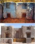
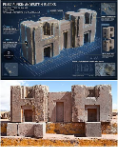
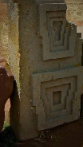
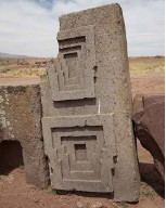
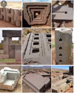
In Andean architecture, particularly within the ruins of Pumapunku and the broader Tiwanaku complex, this design is frequently carved into stone lintels, niches, and faux “windows” as a series of concentric, nested frames.
The characteristic step-like tiers—often described geometrically as a series of nested or inverted stepped squares—create a distinct optical illusion of depth. [1, 2, 3, 4]Symbolic Meaning of the Three TiersThe three distinct steps or “inversions” represent the Andean cosmic trilogy, which divides existence into three interconnected realms: [1, 2]
Hanan Pacha (The Upper World): The celestial realm of the gods, stars, and skies, symbolized by the condor.
Kay Pacha (The Middle World): The earthly realm of everyday human life and the physical world, symbolized by the puma.
Uku Pacha (The Underworld): The inner or lower world associated with ancestors, death, and new life sprouting from beneath the earth, symbolized by the snake. …
Geometric designs featuring stepped crosses, stepped diamonds, and inverted step tiers appear widely across the ancient world. While the 12-pointed Chakana itself is unique to the Pan-Andean region, the underlying geometry—the stepped motif—is a cross-cultural design phenomenon. [1, 2, 3]Because triangles, squares, and stepped lines are the easiest geometric patterns to execute using grid-based mediums like stonemasonry, bricklaying, and textile weaving, civilizations separated by oceans developed remarkably similar iconography.1. The Americas (Beyond the Andes)
Mesoamerica (Maya, Aztec, and Zapotec): In ancient Mexico, a prominent architectural motif known as the xicalcoliuhqui (a stepped fret or “step-wave” design) was heavily used to decorate the facades of temples, such as those at Mitla and Chichen Itza. Geometrically, it looks like a half-split Chakana and carried a similar meaning: the connection between the sky, earth, and underworld.
Ancestral Puebloans (Southwest US): At sites like Pueblo Bonito in Chaco Canyon, pottery, petroglyphs, and architectural design frequently featured stepped diamond and cloud motifs. These represented sacred mountains, horizons, and prayer-steps to reach the rain spirits. [1]
2. The Middle East and Mediterranean
Mesopotamian Ziggurats and Persian Architecture: The concept of a stepped outline representing layers of the cosmos was deeply embedded in Mesopotamian and ancient Persian architecture. The stepped crenellation or merlon design—staircase patterns carved along the tops of palace and temple walls (found in Babylon and Persepolis)—is geometrically identical to the isolated arms of the Chakana. [1]
Egyptian Hieroglyphs: The stepped pyramid design itself represents the primeval mound (Benben) from which life emerged. The Step Pyramid of Djoser fundamentally mimics this geometric logic on a monumental scale. [1, 2]
3. Central and South Asia
Ancient Armenia & Georgia: A design known as the stepped cross (Ghaghabed) appears heavily in early religious architecture across the Armenian Highlands. Carved into stone markers (Khachkars) and early church facades, it featured a multi-tiered base or stepped arms, representing a ladder to heaven or the cosmic tree.
Indian Temple Mandalas: The sacred architectural layouts (Vastu Purusha Mandala) used to design Hindu temples often rely on concentric stepped squares and star-shaped geometry. Looking at the top-down blueprint of a temple like the Hoysaleswara Temple reveals an intricate, multi-stepped cross design engineered to align the building with the cardinal directions. [1]
Region / Culture
Architectural Motif Name
Geometric Feature
Primary Symbolic Meaning
Andean (Tiwanaku / Inca)
Chakana
12-cornered stepped cross
Three realms of existence / Southern Cross constellation
Mesoamerican (Maya / Zapotec)
Xicalcoliuhqui
Stepped fret / spiral waves
Cosmic cycles, lightning, and water networks
Mesopotamian / Persian
Stepped Merlon
Inverted/upright step tiers
Boundary markers between earthly rule and celestial gods
Ancient Indian (Vedic)
Vastu Mandala
Concentric stepped squares
Star maps, cardinal alignments, and cosmic order
Nearly all of these shapes serve as a geometric bridge between the earth and the heavens.While the human instinct to divide reality into layers is incredibly common, different ancient cultures used these stepped shapes to express unique aspects of their own mythologies, environments, and sciences.Here is how their meanings differ from the Andean trilogy:🌽 The Mesoamerican View: Cycles and LifelinesIn Mesoamerica, the stepped Xicalcoliuhqui design was rarely a simple map of three physical realms. Instead, it represented movement and life-giving elements:
Water and Weather: The spiral, stepped shape mimicked the movement of whirlpools, conch shells, and the rolling of storm clouds.
Agriculture: It represented the lifecycle of maize (corn)—sprouting, growing, harvesting, and returning to the earth.
The Sun’s Path: Rather than static tiers, it tracked the cyclical journey of the sun across the sky and through the night.
👑 The Mesopotamian & Persian View: Royal and Divine PowerFor civilizations like Babylon and Persia, the stepped crenellations on walls were not religious maps of an underworld. They were symbols of authority:
The Cosmic Mountain: The steps symbolized the artificial mountains (Ziggurats) built by kings to physically elevate themselves closer to the sky gods.
Protection: Placed atop fortresses and palaces, the jagged, stepped lines symbolized defensive strength and the King’s role as the earthly guardian appointed by the heavens.
📐 The Ancient Indian View: A Geometric Map of the UniverseIn Vedic architecture, the stepped squares of the Vastu Purusha Mandala are not about an upper or lower world, but about perfect cosmic order and symmetry:
The Microcosm: The shape represents a metaphysical man (Purusha) pinned to the earth by the gods, showing how human life fits into the geometric laws of nature.
Energy Grids: It acts as a compass or energy grid, where each concentric step or square represents a different deity or planetary force governing the cardinal directions.
🌦️ The Ancestral Puebloan View: Shamanic Pathways and RainIn the American Southwest, the stepped terrace motif is profoundly tied to survival in an arid landscape:
Cloud Altars: The steps represent towering cumulus clouds, serving as a visual prayer for rain.
Emergence: Rather than an “underworld” of the dead, their mythology emphasizes a place of origin beneath the earth (Sipapu) from which humanity emerged into the current world, viewed as a physical transition rather than a spiritual hierarchy.
Stepped geometric shapes are highly prominent in ancient Egyptian architecture and writing. However, the Egyptians interpreted these steps through their own cultural lens, associating them with resurrection, cosmic ascension, and the dawn of creation rather than a strict three-tiered world system. [1, 2]1. The Step Pyramid: A Launchpad to the SkyThe most famous architectural manifestation of this shape is the Step Pyramid of Djoser at Saqqara, built around 2670 BCE. Geometrically, it is a stack of progressively smaller, flat-roofed rectangular structures called mastabas. [1]
What it represented: According to early funerary beliefs (recorded later in the Pyramid Texts), the steps formed a literal cosmic staircase. The deceased pharaoh’s soul would use these stone tiers to climb out of the earthly realm and ascend to the heavens. Specifically, they wanted to reach the “Imperishable Stars” (the circumpolar stars that never set), achieving eternal life among the gods. [1, 2, 3, 4]
2. The Benben Stone and the Primordial MoundIn Egyptian mythology, before the universe existed, there was only a dark, chaotic ocean called Nu. The first thing to emerge from this void was a hill of earth called the primordial mound (Benben). [1]
What it represented: The very first rays of the sun god struck this mound, bringing light and life to the world. In art and architecture, this creation hill was often stylized as a multi-tiered stepped platform. When you see Egyptian gods or pharaohs sitting on stepped thrones, they are sitting on a geometric representation of the birthplace of the universe, signifying supreme divine authority. [1, 2]
3. Hieroglyphics: The Staircase SymbolThe Egyptians also used the single stepped line directly in their written language. [1]
The “Staircase” Hieroglyph (Sign O40): This glyph looks exactly like a profile view of a stepped pyramid tier or half-Chakana. It was used to write words like mewet (ascent) or khayt (terrace/stairway). It visually represented a bridge between two planes of existence—enabling communication between humans on earth and the divine realms above. [1]
Direct Architectural Comparison
Feature
Andean Chakana (Pumapunku)
Egyptian Step Pyramid (Saqqara)
Primary Meaning
The three interconnected worlds (Celestial, Earthly, Underworld).
A physical staircase built for the soul to climb into the heavens.
Creation Symbolism
Tied to the Southern Cross constellation and seasonal agriculture.
Tied to the primordial mound rising out of the waters of creation.
Evolution
Remained a central holy symbol throughout Tiwanaku and Inca history.
Evolved into smooth-sided pyramids to mimic the rays of the sun god, Ra.
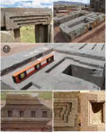
These exact geometric stepped shapes and “faux windows” appear prominently in the ancient region of Van, Turkey. [1, 2]In antiquity, the area surrounding Lake Van was the heart of the Iron Age Kingdom of Urartu (circa 860–590 BCE). The Urartians were legendary master stonemasons who carved massive geometric niches, stepped platforms, and faux doorways directly into the living rock. [1, 2]The most famous example is the Meher Kapısı (the Meher Gate), a colossal, monolithic rock-cut niche located just outside the city of Van. Visually, it features the exact same nested, stepped, and concentric frame structure seen in the “windows” of Pumapunku. [1, 2]What Did They Represent to the Urartians?Unlike the Andean worldview of a three-tiered physical trilogy, the Urartians carved these stepped geometric frames to serve as “Gates of the Gods” and cosmic portals.
Portals for the Divine: The Meher Gate contains a long cuneiform inscription dictated by the Urartian kings. It outlines a supreme religious calendar, listing 79 different deities and the exact animal sacrifices required for each. Because the niche is solid rock and leads nowhere, it was viewed as a literal portal through which the supreme god, Khaldi, and other celestial beings could transition from their spiritual realm into the earthly world.
The “Sacred Mountain” Connection: Urartian religion was deeply tied to the worship of mountains, rocks, and volcanic peaks (like nearby Mount Ararat). By carving massive stepped geometry into the mountainside, they stylized the rugged horizon into a perfect geometric order, turning natural rock formations into holy altars.
Stepped Crenellations (Fortress Power): In their practical architecture, the Urartians built massive stone fortresses (such as the Van Fortress or Van Kalesi). The tops of these walls featured stepped battlements. In their iconography, these steps represented the crown of divine protection shielding the king’s kingdom from external chaos.
Architectural Commonalities: Van vs. PumapunkuThe striking visual similarities between the rock-cut niches in Van, Turkey, and the nested frames at Pumapunku, Bolivia, have made both sites central to discussions among alternative historians. [1]
The Mainstream Archaeological View: This is an example of independent invention. When human cultures worldwide attempt to carve straight lines and geometric angles into hard volcanic stone without advanced machinery, the most stable, aesthetically striking, and structurally sound pattern to repeat is the stepped tier.
The Alternative View: Writers and researchers point to these recurring motifs—including the stepped frames, “T-shaped” architectural slots, and precise stone joins found in both Turkey and South America—as potential remnants of a shared, prehistoric master-building tradition. [1]’
AI – ‘In academic art history, the tension between objective empirical representation and the romanticised sublime is primarily understood through the late 18th and 19th-century transition from the Enlightenment to Romanticism, and the subsequent rise of Realism and Impressionism.
This tension represents a fundamental debate over the purpose of art: whether it should document the observable, physical world or capture the unquantifiable emotional and spiritual experience of existence.
1. The Philosophical FoundationsThe intellectual framework for this artistic tension was established by Enlightenment and Romantic philosophers, who dualistically defined how humans process reality:
The Empirical/Beautiful: Rooted in John Locke’s empiricism and later codified by Edmund Burke and Immanuel Kant, the empirical or “Beautiful” relies on order, clarity, proportion, and observable form. It is rational, measurable, and speaks to the intellect.
The Romanticised Sublime:Edmund Burke’s 1757 treatise (A Philosophical Enquiry into the Origin of Our Ideas of the Sublime and Beautiful) defined the Sublime as an experience of awe, terror, and vastness that overwhelms human reason. Immanuel Kant expanded this, viewing the Sublime as a cognitive state where the mind confronts the limitless scale of nature, realizing human physical insignificance yet elevating human moral and spiritual reasoning.
2. The Core Artistic Movement: Romanticism vs. Academic Neo-ClassicismThe conflict materialized visually in the late 18th century as artists rebelled against the strict, empirical, and rational boundaries of Neo-Classicism and Enlightenment science.
+------------------------+-----------------------------------------------------------+-----------------------------------------------------------+

| Attribute              | Objective Empirical Representation                        | The Romanticised Sublime                                  |
+------------------------+-----------------------------------------------------------+-----------------------------------------------------------+

| Core Artistic Movement | Neo-Classicism, Enlightenment Art, later Realism          | Romanticism                                               |
| Visual Characteristics | Sharp focus, linear perspective, anatomical accuracy      | Atmospheric blur, dramatic light (chiaroscuro), vast scale|
| Primary Subject Matter | Historical facts, scientific anatomy, observable nature    | Raging storms, infinite horizons, ruins, internal psyche  |
| Goal of the Artist     | To instruct, document truth, and uphold rational order    | To evoke awe, terror, and spiritual transcendence         |
+------------------------+-----------------------------------------------------------+-----------------------------------------------------------+
3. Key Case Studies in Art HistoryThe Sublime Mediated by Empirical Observation: J.M.W. TurnerThe British painter J.M.W. Turner perfectly encapsulates this tension. Turner was deeply interested in the scientific advancements of his day (such as optics, meteorology, and steam power). However, he used this empirical knowledge to paint the Sublime. Works like Rain, Steam, and Speed (1844) take an empirical subject—a modern train—and dissolve its physical form into an overwhelming, atmospheric vortex of light and motion, capturing the terrifying power of human innovation.The Transcendent Landscape: Caspar David FriedrichIn Germany, Caspar David Friedrich used precise, highly detailed draftsmanship (empirical representation) to render landscapes that were meant to evoke a profound religious and spiritual Sublime. In Wanderer above the Sea of Fog (1818), the hyper-accurate rendering of the rocky foreground clashes with the infinite, unknowable expanse of fog, symbolizing the human confrontation with the divine.The Scientific vs. The Dramatic: The French DebateIn France, the tension played out between the linear, objective classicism of Jean-Auguste-Dominique Ingres (who valued crisp contours and rational anatomy) and the fluid, emotional colorism of Eugène Delacroix (who painted violent, exotic, and emotionally turbulent scenes of the Sublime).
4. The Legacy: The Shift to Realism and PositivismBy the mid-19th century, the pendulum swung back toward empirical objectivity with the rise of Realism. Driven by Gustave Courbet and the philosophy of Positivism, artists rejected the romanticised sublime entirely. Courbet famously stated, “I cannot paint an angel because I have never seen one,” demanding that art return to the strict, objective, and empirical depiction of everyday working-class life.Later, Impressionism attempted a unique synthesis: using an empirical, almost scientific approach to how light hits the human retina, while producing fleeting, atmospheric landscapes that viewers often experienced as deeply poetic or sublime.
To explore the tension between objective empirical representation and the romanticised sublime in the Corfu landscapes of the Ionian School of art, you can structure your analysis around how the island’s unique physical environment acts as a battleground between scientific observation and emotional idealism.The Ionian School (18th–19th centuries) stood at a unique art-historical crossroads. It shifted away from rigid Byzantine traditions toward Western European styles, heavily influenced by Italian Renaissance naturalism, British Romanticism, and the French Enlightenment. Corfu’s specific geography provides the perfect case study for this transition.Here is how you can analyse these specific environmental features to expose that artistic tension:
1. The Atmospheric Light of Coastal Horizons
Corfu’s coastal light is distinct due to its high marine humidity, geographic proximity to the mountainous Greek mainland, and intense Mediterranean sun.
The Empirical Reality: Artists tracking an empirical or proto-realist approach had to contend with the physical properties of this light. The high humidity creates a natural phenomenon called atmospheric perspective, where distant landmasses (like the mountains of Epirus across the strait) lose contrast and shift toward cool blue and violet wavelengths. An empirical study requires precise tonal gradation and an understanding of how moisture refracts light.
The Romantic Sublime: Conversely, this same humidity creates a soft, diffusing “envelope” of light that dissolves hard edges—a technique highly prized by Romantic landscape painters to evoke the sublime. The glowing, hazy horizons capture a sense of the infinite and the untouchable.
The Tension: Look at how an Ionian artist handles the horizon line. Is the coast of Epirus rendered with geographical accuracy (empirical), or is it swallowed by a golden, blinding solar glare that emphasizes human insignificance before nature (the sublime)? The tension lies in whether the light is used to illuminate structure or to dissolve reality into emotion.
2. The Botanical Topographies of Olive Groves
Unlike the manicured, symmetrical orchards of Central Europe, Corfu’s olive groves—many planted during the Venetian era—are ancient, gnarled, and overgrown.
The Empirical Reality: An empirical approach treats the olive grove as a botanical and geological survey. The artist focuses on the specific, tactile texturing of the silver-green leaves, the rough, fractured bark of centuries-old trunks, and the karst limestone topography breaking through the soil. This requires sharp draftsmanship, accurate botanical scaling, and localized color palettes.
The Romantic Sublime: To the Romantic eye, these ancient groves are not just trees; they are living ruins. Their twisted, hollowed trunks resemble gothic architecture or agonized human figures, evoking the “terrible beauty” of time, decay, and nature’s endurance. The dense canopy creates deep, dramatic pockets of chiaroscuro (light and shadow) that feel mysterious, melancholic, and untamed.
The Tension: Analyse the brushwork and composition of the groves. Does the artist isolate a tree to document its exact organic form, or do they submerge the viewer into a claustrophobic, shadowed forest where the trees feel like sentient, overwhelming forces? The tension is found between documenting a botanical specimen and channeling an existential mood.
3. The Microclimates and Shifting Weather Systems
Corfu experiences dramatic microclimates, featuring sudden, violent winter storms, low-hanging sea mists, and heavy rain alongside intense summer heat.
The Empirical Reality: Capturing these states realistically requires observing the physics of weather—how a sudden south wind (Sirocco) whips up specific wave formations on the sea, or how low-pressure systems alter cloud taxonomy.
The Romantic Sublime: In Romantic theory (particularly via painters like J.M.W. Turner, who influenced Mediterranean travel art), a storm at sea or a mountain shrouded in mist is the ultimate manifestation of the sublime. It triggers a aesthetic frisson—a thrilling sense of terror experienced from a safe distance.
The Tension: Evaluate the sea and sky. If an Ionian painting depicts a storm hitting the Corfiot coast, does it lean toward a maritime logbook precision (how ships and waves physically interact), or does the weather turn chaotic and expressive, where the sea and sky blur together to mirror the internal, psychological tempest of the human soul?
When examining specific paintings by Ionian School masters (such as Angelos Giallinas, known for his atmospheric watercolors, or Charalambos Pachis), ask yourself these three guiding questions:
Where does the detail end? If the foreground is obsessively detailed (empirical) but terminates in an infinite, hazy void (sublime), the artist is balancing both worlds.
Is the palette observational or emotional? Are the colors true to the sun-baked, dusty reality of a Greek summer, or are they exaggerated into theatrical, emotional jewel tones?
What is the human scale? Are humans placed in the landscape as active, empirical workers (e.g., peasants harvesting olives), or are they tiny, passive onlookers dwarfed by a colossal, roaring coastline?’
AI – ‘Arthur Posnansky’s core theory was that Tiwanaku (including Puma Punku) was the “Cradle of American Man,” built roughly 15,000 to 17,000 years ago by a highly advanced, primordial race. Published in his magnum opus Tiahuanaco: The Cradle of American Man (1945), his alternative narrative radically conflicted with modern archaeology, which dates the site to around 500–600 AD. [1, 2, 3, 4]
Posnansky’s theory about the builders and the timeline breaks down into several key components:
1. Built by a “Superior” Extinct Race
Posnansky argued that the complex was constructed by an advanced, “superior” race of American peoples. Crucially, he insisted that they were not the ancestors of the local Aymara people living in the region at the time of his research. His theories were heavily informed by his own controversial concepts of Andean racial anthropology, viewing the original builders as a distinct, highly intellectual group that has since vanished. [1, 2]
2. The Global Origin Point of CivilizationRather than seeing Tiwanaku as a localized pre-Inca culture, Posnansky believed it was the apex birthplace of all civilization across the Americas.
He argued that the cultural, architectural, and religious frameworks developed at Tiwanaku ultimately radiated outward to seed and influence later major civilisations, including the Incas, Mayans, and Aztecs. [1]
3. Timeline Proven by “Archaeoastronomy”
To justify who built it, Posnansky had to explain the immense age he assigned to it. Before the invention of radiocarbon testing, he used archaeoastronomy. He measured the solar alignments of the Kalasasaya temple and the Gate of the Sun, calculating that the structures perfectly aligned with the summer and winter solstices only as they would have appeared in 15,000 BC. Thus, he argued the builders had to have lived during the Ice Age when the Altiplano had a semi-tropical climate. [1, 2, 3]4. Destruction by CataclysmPosnansky theorised that this advanced civilization underwent three distinct periods of occupation. He believed the builders of the final, most sophisticated phase (which includes the precision masonry at Puma Punku) were abruptly cut short by a massive cosmic or geological cataclysm, such as a catastrophic flood from Lake Titicaca, which buried the site in mud and brought an end to their empire. [1, 2]
Note: Mainstream scientists and modern archaeologists completely reject Posnansky’s timeline and racial theories. Radiocarbon testing has firmly proven that Puma Punku was built around 500–600 AD by the actual ancestors of the regional indigenous groups—the historical Tiwanaku culture—using clever stonework layering and standard, though highly skilled, Andean engineering practices. [1, 2, 3, 4] …
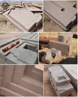
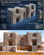
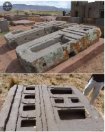
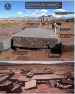
The precise, modular “H-blocks” found at Puma Punku and Tiwanaku are completely unique; they do not appear anywhere else in ancient megalithic architecture.
While the “H” shape itself as a standalone structural block is isolated to this specific Bolivian site, the concepts behind them—prefabrication, modular interlocking design, and the use of metal connectors—can be found in several other famous ancient sites around the world. [1]
When looking for the engineering principles of the H-blocks globally, archaeologists point to these key connections:
1. “I” and “T” Shaped Keystone Clamps (Global)The H-blocks at Puma Punku feature specialized grooves meant to hold cold-poured copper-arsenic bronze clamps to lock the masonry together. While Puma Punku used these internally on modular blocks, the technique of carving I-shaped, T-shaped, or bowtie-shaped clamp sockets into megalithic stones is found globally: [1, 2]
The Andes: Nearby Inca and pre-Inca sites like Ollantaytambo and Sacsayhuamán in Peru use identical metal clamp channels to secure massive walls.
Ancient Egypt: The Temple of Luxor and various structures at Aswan feature wooden and metal “dovetail” tie-bars used to bind monumental stone blocks. [1]
Classical Greece & Rome: The Parthenon in Athens used iron clamps poured with molten lead to securely lock its marble blocks against earthquakes.
Persia (Iran): The ancient capital of Pasargadae and the palace of Persepolis utilize highly advanced “swallowtail” or butterfly-shaped iron clamps to connect monumental masonry.
2. Interlocking “Zig-Zag” and Polygonal JointsPuma Punku’s blocks rely on geometric angles to jigsaw together. This philosophy of interlocking shapes rather than square bricks appears in: [1, 2]
Valley Temple of Giza (Egypt): The massive granite blocks feature complex, three-dimensional corner joints where the stones wrap around each other in an interlocking fashion, eliminating straight seam vulnerabilities.
Inca Architecture (Peru): The famous Twelve-Angled Stone in Cusco showcases how South American builders preferred polygonal interlocking joints to create earthquake-proof walls without mortar.
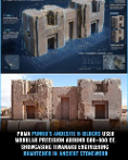
3. Modular “Friezes” (The True Purpose of H-Blocks)Architectural reconstructions by scholars (such as Dr. Alexei Vranich) have revealed that the H-blocks were not meant to be giant freestanding puzzles. Instead, they were modular elements of a collapsed, grand gateway or decorative frieze. [1]
Similar structural “frieze” modules—where identical geometric shapes are mass-produced to snap into a larger wall structure—can be seen heavily in Mayan architecture, such as the intricate stone lattice networks at Uxmal and Chichen Itza in Mexico.
In summary, while you will find the metal clamp technology and interlocking logic scattered across Egypt, Greece, and Peru, the precise “H” geometry remains an exclusive, localized signature of the Tiwanaku civilization’s genius. …
To move 100-ton megalithic stone blocks over a mountain range and across long distances today, modern engineering would bypass traditional cranes and rely on heavy-lift logistics, specialized heavy transport machinery, and maritime engineering. [1, 2]First, a quick logistical correction: geological and petrographic analyses show that the largest 100+ ton red sandstone blocks at Pumapunku actually came from a quarry roughly 10 kilometres away.
The stones that came from the Copacabana Peninsula 90 kilometres away across Lake Titicaca were the smaller, ornamental volcanic andesite blocks. [1, 2]
Here is exactly how modern engineering would execute both transport routes today using state-of-the-art equipment:1. Moving the 100-Ton Sandstone Blocks (10 km Overland Route)To transport a single 100-ton block up the steep, high-altitude incline from the local sandstone quarry, modern contractors would use a Self-Propelled Modular Transporter (SPMT). [1, 2]
The Equipment: An SPMT is a platform vehicle packed with dozens of computer-controlled wheels. Companies like Mammoet use these regularly to move entire factories, ships, and space shuttles.
The Execution: A 4-axle or 6-axle SPMT configuration would easily support 100 tons. Because each axle unit can swivel 360 degrees and has independent hydraulic suspension, the vehicle can remain perfectly level while climbing steep, uneven mountain inclines, ensuring the stone doesn’t slip.
2. Moving Stones via the 90 km Route (Across Lake Titicaca)
For the stones originating 90 kilometres away, the journey requires a multi-modal transport strategy combining land and water: [1]
[Copacabana Quarry] ➔ SPMT Transport ➔ [Heavy Lift Barge] ➔ Lake Crossing ➔ SPMT Transport ➔ [Puma Punku]
Water Crossing: The stones would be driven directly onto a heavy-transport deck barge using an SPMT. Tugboats would tow the barge across Lake Titicaca.
The High-Altitude Challenge: Lake Titicaca sits at 3,812 metres above sea level. Operating heavy machinery here is difficult because the thin air drops diesel engine efficiency by up to 30–40%. Modern engineers would have to use heavily turbocharged engines or electric-assisted powertrains to prevent equipment from stalling on the climb from the shoreline to the site.
3. Lifting and Placing the Stones at the SiteOnce at Puma Punku, standard construction cranes would struggle due to the uneven high-altitude ground and the massive footprint of the blocks. Instead, engineers would use: [1, 2]
Gantry Crane Systems: A portable hydraulic gantry framework would be built over the foundation. This allows engineers to lift the block cleanly and slide it into place with millimetre precision.
Hydraulic Jacking: For tight spaces, high-capacity hydraulic strand jacks would lift the blocks from underneath, allowing workers to align the famous interlocking joints safely
Without modern machinery, the ancient Tiwanaku civilization relied on hyper-organized collective labour, specialized mechanical physics, and local topography. Because the Tiwanaku did not use draft animals or the wheeled wheel for cargo transport, their engineering methods were heavily reliant on ingenious friction-reduction techniques. [1, 2, 3]Archaeologists, along with experimental architectural researchers like Jean-Pierre Protzen and Stella Nair, have reconstructed the three primary engineering methods used to move and lift these multi-ton blocks: [1]1. The Overland Route: Sledges, Ramps, and Frost EngineeringFor the massive 100+ ton sandstone blocks hauled over the 10-kilometre route from the Khonko Wankane quarry, engineers point to a combination of heavy-duty mechanics: [1, 2]
The “Mud and Wet Clay” Sledges: The Tiwanaku constructed large wooden sledges out of high-density Andean timber. Instead of using wooden rollers (which would crush under 100 tons), they dragged the sledges over prepared tracks of wet, slick clay or llama fat to drastically reduce friction. [1, 2]
The Ice Friction Theory: Some engineers have proposed a seasonal transport theory utilizing the Altiplano’s unique climate. At nearly 4,000 metres, temperatures drop below freezing every night. By pouring water along the tracks in the evening, they could create a slick ice runway, allowing hundreds of men using llama-skin ropes to slide 100-ton blocks with minimal resistance. [1]
Calculated Mass Manpower: Physicists calculating the necessary drag force estimate that moving a 100-ton block on a lubricated sledge would require roughly 1,500 to 2,000 people pulling in unison. Tiwanaku was a highly centralized state capable of mobilizing tens of thousands of workers for seasonal public labor. [1, 2]
2. The Maritime Route: Megalithic Totora Reed BargesFor the smaller, ultra-hard andesite stones transported 90 kilometres across Lake Titicaca from the Copacabana Peninsula, the engineering was entirely aquatic: [1, 2]
Totora Reed Construction: The indigenous people of the lake have built massive, highly buoyant boats out of woven totora reeds for millennia (similar to the famous Uros floating islands). [1]
The Floatation Method: Rather than attempting to lift a 10-to-40-ton block onto a boat—which would tip the vessel—the Tiwanaku likely rolled the stone into a shallow harbor at low tide. They would then position a large, hollow reed barge directly over the stone at high tide, securing it with ropes. When the tide or lake level rose, the buoyant barge naturally lifted the stone off the lakebed, suspending it underwater where it effectively “weighed” less due to water displacement. [1]
The Iwawi Port: Archaeologists discovered an ancient Tiwanaku port site called Iwawi on the shores of Lake Titicaca. Dozens of abandoned andesite blocks were found lining a direct, paved ramp road leading from this port straight to the Pumapunku complex, confirming a multi-modal ship-to-shore transit pipeline. [1]
3. Lifting and Precise Placement: Lever Pockets and Sand JacksLifting a 130-ton sandstone foundation slab into place without a crane relies on basic physics and gravity: [1]
Lever Pockets: Many of the large blocks feature subtle rectangular notches cut into their bottom edges. Archaeologists believe these were intentionally carved to fit heavy wooden levers, allowing teams of workers to pry the stones upward inch by inch.
The Sand Jack Method: To lower blocks into perfectly level positions, the Tiwanaku may have utilized sand boxes. A stone would be maneuvered onto a platform supported by a chamber filled with dry sand. By slowly draining the sand out of small holes in the bottom of the chamber, engineers could lower the massive block into place with millimetre precision, preventing it from crashing down and fracturing.
The precise geometric cuts, sharp right angles, and uniform grooves seen in the volcanic andesite blocks at Pumapunku have triggered endless speculation. Because copper and bronze tools are far softer than hard volcanic rock like andesite, early historians assumed the work was impossible without advanced machine tools. [1, 2, 3, 4, 5]However, architectural researchers Jean-Pierre Protzen and Stella Nair conducted breakthrough experiments replicating these cuts. Their research reveals that the Tiwanaku achieved this astounding precision through standardized, step-by-step lithic technology, brilliant physics, and pure patience. [1, 2]
1. The Pounding and Flaking Stage (Rough Shaping)Before achieving perfectly straight lines, the raw block had to be brought down to size.
The Tools: Artisans used heavy hammerstones composed of even harder minerals, such as hematite, basalt, or quartzite.
The Method: By rhythmically striking the block, they chipped away mass through controlled fracturing. They did not try to “cut” the stone yet; they hammered it into a rough, rectangular form slightly larger than the final intended design. [1]
2. The “Super-Abrasion” Stage (The Machine-Like Finish)The impossibly flat surfaces that look like they were polished with modern lasers were actually done through an intense grinding process. [1]
The Tools: Flat, heavy slabs of quartzite paired with sand and water slurry acted as an ancient sandpaper.
The Method: Workers would continuously slide the quartzite flat-stones back and forth over the rough andesite, using the loose sand grains as a coarse abrasive. As the sand broke down into a fine powder, it naturally polished the volcanic stone to a mirror-like smoothness. [1]
The Tools: Stella Nair’s experiments successfully replicated these cuts by using thin, sharp chisels and blades made of flint, agate, jasper, obsidian, and hematite. [1]
The Method: Artisans carefully flaked these mineral crystals into narrow, razor-sharp points. Because these micro-crystalline minerals have a incredibly high rating on the Mohs hardness scale, they can carve, micro-chip, and score lines directly into the tough andesite matrix without blunting instantly. [1]
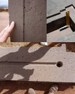
4. Perfectly Drilled Holes and Blind PocketsMany blocks feature highly precise, small holes that look like drill marks. [1]
The Tools: Hollow bone fragments, stiff reeds, or copper tubes paired with corundum or quartz sand dust.
The Method: By placing a hollow pipe onto the rock, filling it with abrasive sand dust, and rapidly spinning it (likely using a simple bow-drill string mechanism), the sand would wear away a perfect circle into the rock. This technique of “core drilling” was widely used across the ancient world.
The Controversial Alternative: Geopolymer ConcretingWhile mainstream archaeology firmly supports the stone-carving method, a minority engineering theory presented by materials scientist Joseph Davidovits suggests a completely different approach. [1]He theorized that the Tiwanaku didn’t carve the stones at all. Instead, his chemical analyses suggest they may have used organic plant acids to dissolve local weathered volcanic rock into a slurry, mixed it with a mineral binder, and poured it into wooden molds. As the mixture cured over months, it hardened back into solid stone, perfectly mirroring the flat edges of the mold. However, this theory remains highly debated and is generally rejected by field archaeologists who have found physical hammer marks and stone dust at the quarries. [1]
To shape volcanic andesite—which sits at a tough 6 to 6.5 on the Mohs hardness scale—the ancient Tiwanaku people could not rely on copper or soft bronze tools (which only rate between 3 and 4). Using a copper chisel on andesite would be like trying to carve a stone wall with a plastic knife; the tool would blunt or bend immediately. [1, 2, 3]Instead, architectural researchers Jean-Pierre Protzen and Stella Nair proved through experimental archaeology that the Tiwanaku’s “secret weapons” were hard lithic hammerstones and high-silica mineral abrasives. They bypassed metal entirely for the heavy cutting, categorizing their tools into three distinct types: [1, 2, 3]1. Hard-Mineral Hammerstones (For Chipping & Fracturing)To remove bulk material and rough out the shapes of the blocks, masons used heavy, handheld hammerstones made from materials significantly denser and tougher than the andesite itself: [1]
Hematite & Basalt: Heavy iron oxides and dense volcanic rocks were collected from local riverbeds or specific quarries.
Quartzite Knapping Hammers: Quartzite scores a 7 on the Mohs scale. By striking the andesite at precise, calculated angles, these hard hammers could micro-fracture the rock, slowly chipping away large pieces without the hammer itself shattering. [1, 2, 3]
2. Micro-Crystalline Chisels (For Sharp Lines & Right Angles)To achieve the famous, straight interior 90-degree cuts seen on the H-blocks, the Tiwanaku didn’t use metal bars. They used razor-sharp, flaked fragments of crystals: [1, 2]
Flint, Agate, Jasper, and Obsidian: These micro-crystalline quartz varieties all register a 7 on the Mohs scale. Masons carefully knapped these minerals into narrow, pointed chisels or scraper blades. Because they are harder than the andesite’s mineral matrix, these fine crystal points could score deep, perfectly straight lines and carve out crisp internal right angles with painstaking patience. [1, 2]
3. Loose Mineral Slurry (The True “Cutting” Agent)For flat, glass-smooth finishes and perfectly straight grooves, the primary tool wasn’t a solid object at all—it was a loose abrasive powder: [1]
Quartz Sand Dust: Workers placed loose quartz sand mixed with water onto flat slabs of quartzite or even other pieces of flat andesite rock. [1]
The Abrasive Friction Method: By pushing a flat “rubbing stone” back and forth over the block, the tiny, loose quartz grains became trapped in between. The friction caused the quartz grains to continuously wear down the high points of the andesite surface. As the sand ground down into a super-fine powder, it naturally polished the volcanic stone to a mirror-like finish, wiping away any trace of rough hammer marks.
The Tiwanaku and Pumapunku complexes were not built as cities for everyday living. Instead, they were designed as a massive, highly sophisticated ritual pilgrimage hub and a symbolic “axis mundi”—the center of the Andean cosmos.To the Tiwanaku culture, this high-altitude landscape was where the universe was created. Every architectural alignment, precise stone cut, and subterranean channel was engineered to perform three main interconnected functions:1. A Cosmic Portal for State-Sponsored PilgrimagePumapunku served as the grand entrance to the sacred precinct. It was a spiritual sorting ground for tens of thousands of pilgrims who traveled from all over the Andes.
The Ritual Transformation: Excavations show that visitors did not just walk into the site; they underwent intense, multi-day purification rituals. The famous interlocking geometric stone rooms and porticoes acted as visual and psychological thresholds, transitioning pilgrims from the mundane world into the realm of the gods.
Shamanic and Psychotropic Rituals: Archaeologists have excavated numerous complex “shaman kits” containing snuff tablets, bone tubes, and spatulas used to consume powerful psychotropic plants like Anadenanthera (vilca) and San Pedro cactus. The architectural layout was designed to heighten these altered states of consciousness through overwhelming scale and geometric symmetry.
2. A Giant Astronomical and Agricultural ClockAt 3,800 metres above sea level, surviving in the harsh Altiplano requires mastering the unpredictable mountain climate. The sites were massive stone computers built to track and predict seasonal cycles:
The Kalasasaya Temple: This nearby walled structure acts as a literal solar calendar. On the morning of the equinoxes and solstices, the sun rises precisely in the center of dedicated stone gateways, giving priests the exact dates needed to decree when to plant or harvest crops.
Water Manipulation as Ritual Theatre: The complex engineering of Pumapunku included intricate, hidden networks of stone-carved drainage channels. During the intense Andean rainy season, these channels collected rainwater and diverted it down the terraced faces of the pyramids. This created artificial, roaring waterfalls that cascaded down the stone structures, visually mimicking the sacred peaks of the surrounding Andes and celebrating water as the giver of agricultural life.
3. An Architectural Anchor of Political PowerThe precision engineering itself was a display of supreme political dominance.
The “H-Blocks” and Modular Construction: The hyper-precise, standardized H-blocks and interlocking gateways were likely meant to represent structural harmony and order. By demonstrating that they could control and shape the hardest stones into uniform, perfect geometry, the Tiwanaku elite visually proved their mandate to rule over the chaotic natural world.
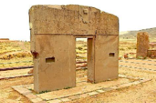
The Gateway of the Sun: Acting as the focal point of the religious complex, this single-block stone gateway features a carving of the “Staff God” (often associated with Viracocha), flanked by winged running figures. It served as a permanent visual reminder of the divine hierarchy that kept the empire unified.
The water management infrastructure engineered by the Tiwanaku is considered by modern hydrologists to be one of the most advanced examples of pre-Columbian civil engineering in the Americas. [1]Rather than just digging basic dirt ditches, Tiwanaku and Pumapunku were designed as integrated, hydro-engineered stone platforms. By using Computational Fluid Dynamics (CFD) modeling, modern engineers have mapped out exactly how these subterranean networks operated, proving that they served critical structural, sanitary, and ritual functions: [1, 2, 3]1. Structural Preservation: Preventing “Soil Liquefaction”The biggest threat to massive 100-ton stone blocks sitting on high-altitude soil is water saturation. During the intense Andean rainy season, rainwater soaking into the ground can turn the soil into mud, causing the heavy foundation stones to shift, tilt, or sink. [1, 2]
The Solution: The Tiwanaku constructed a large perimeter drainage channel that completely encircled the ceremonial core of the city.
The Mechanics: This perimeter trench acted like a modern French drain. It intercepted both surface rainwater runoff and underground aquifer seepage. By keeping the water table at a constant, stable depth year-round, they ensured the foundation soil remained firm enough to hold up the massive pyramids. [1, 2]
2. The Internal Network: Leak-Proof Stone PipelinesBeneath the ceremonial plazas and palaces like Putuni lie masterfully constructed stone pipelines running up to 2.5 metres underground. [1]
The Construction: The main subterranean conduits (such as “Channel P”) were built using large, smooth vertical sandstone slabs roughly 1.0 metre high, capped tightly with flat horizontal stones. [1]
Perforated Stone Disks: To drop water from the surface into these deep channels, they built vertical drop-pipes out of stacked, interlinked stone rings. The joints were so perfectly fitted that the pipelines were virtually leak-proof, safely rocketing water away without eroding the surrounding dirt structures from the inside out. [1]
3. Taming the “Hydraulic Jump”When water flows rapidly down a steep incline and suddenly hits a flat surface, physics dictates a phenomenon known as a hydraulic jump. The water loses velocity, rises violently into turbulent waves, and generates intense kinetic energy that can easily tear apart stone infrastructure. [1]
The Engineering: On the seven-tiered Akapana pyramid, water collected at the summit was directed down through the interior levels via stone-lined stepped conduits. Tiwanaku engineers perfectly calculated the slope, width, and friction coefficients of these steps to deliberately slow the water down in stages. They successfully “tamed” the hydraulic jump, allowing rushing torrents of water to cascade safely down the pyramid without destroying the masonry. [1, 2, 3]
4. Advanced Sanitation and Wastewater FlushingThe Tiwanaku didn’t just manage rainwater; they built a functioning dual-water sewage system. [1]
The Flushing System: Archaeologists discovered that a spring-fed canal (termed the “M Channel”) bypassed the city center and fed fresh water directly into separate subterranean wastewater channels running underneath high-status elite residential compounds. [1]
This fresh water acted as a continuous, gravity-powered flushing mechanism to remove human waste from the living areas, directing it safely out into the Tiwanaku River and eventually into Lake Titicaca. [1, 2]
5. Acoustic and Ritual EngineeringAs noted by archaeologist Alan Kolata, the sheer scale of the stone-cutting and joinery in these water channels was heavily over-engineered. A simple, small ditch could have handled the water, but the Tiwanaku opted for monumental, visible stone artistry. [1]
During heavy storms, the cascading water flowing through the multi-tiered pyramids and out of subterranean stone mouths created a deafening, roaring acoustic effect. The entire site effectively transformed into a living, thundering mountain, putting the civilization’s mastery over the forces of nature on theatrical display for gathered pilgrims. [1, 2]
The precise, modular geometric shapes and patterns discovered at Puma Punku and Tiahuanaco (Tiwanaku) in Bolivia represent a distinct pinnacle of Pre-Columbian Andean architecture. Rather than appearing globally across the ancient Old World, these very specific architectural forms and layouts directly influenced, re-emerged, or shared lineage within a targeted network of Central and South Andean civilizations. [1, 2]The hallmark styles—such as stepped niches, nested right angles, modular blocks, and the iconic Andean Cross—primarily appear in the following areas of the ancient architectural world:1. The Wari Empire (Peru)The Wari (Huari) civilization flourished concurrently with Tiwanaku (c. 600–1000 AD) and shared a highly unified iconographic and architectural vocabulary known as the Southern Andean Iconographic Series. [1, 2]
Where they appear: At the Wari capital city near Ayacucho and provincial outposts like Cerro Baúl.
The Motifs: The Wari integrated the strict, linear stonework layout and rectangular modular geometries directly into their administrative palace enclosures and tombs. The step-molding and nested geometric borders flanking Tiwanaku gateways (like the Gateway of the Sun) were mimicked in Wari architectural reliefs and structural layouts. [1, 2, 3, 4, 5]
2. The Inca Empire (Tahuantinsuyo)The Inca civilization (c. 1438–1533 AD) openly revered Tiwanaku as a mythical place of creation and heavily adapted its mathematical precision and structural motifs into Imperial Inca masonry. [1, 2]
Where they appear: Prominently featured in Cusco (the capital), Ollantaytambo, Sacsayhuamán, and the sacred temple of Coricancha.
The Motifs:
The Double and Triple-Stepped Chambranle: The famous recessed, nested step-frames surrounding doors and windows at Puma Punku became the absolute signature of high-status Inca imperial architecture.
The Chacana (Andean Cross): The multi-leveled indented geometric cross found on Puma Punku’s andesite blocks was heavily adopted by the Inca as a central cosmological layout in their shrines and sacred carved rock outcrops (huacas).
Ashlar Interlocking Masonry: The mortarless, perfectly fitted joints and metal tie-clamps used to lock massive stone platforms together at Puma Punku provided the direct blueprint for the gravity-defying, earthquake-proof polygonal and ashlar stonework of the Incas. [1, 2, 3]
3. Local Formative Precursors: Pukara and Chiripa (Bolivia/Peru)The exact origin of these precise geometric layouts did not appear out of thin air; they evolved from earlier cultures cradled within the Lake Titicaca basin. [1]
Where they appear: The archaeological sites of Chiripa (Bolivia) and Pukara (Peru), dating back to 1500 BC–400 AD.
The Motifs: Archaeologists have excavated early subterranean courtyard structures and stone storage foundations at Chiripa that exhibit the initial layouts of nested rectangles and strict bilateral symmetry. Pukara stonework also yields early iterations of stepped geometric patterns that Tiwanaku builders later perfected into hyper-exact, standardized stone modules.’
I wrote an unpublished essay about this subject – which I call ‘Cultural Heritage Diplomacy’, about three years ago.
At the private preview and unveiling of the Bayeux Tapestry at the British Museum on 2 September 2026, the leaders used the historic loan to champion a diplomatic and cultural ‘reset’ between the UK and France.
Speaking in both English and French, King Charles called the loan the ‘best possible symbol’ of the Entente amicale and a ‘precious symbol of trust’ demonstrating ‘what our countries can do if they join forces.’
President Emmanuel Macron described the tapestry as an epic that ‘bound our cultures, our histories and our destinies together,’ helping the nations to forge a bond as close as the embroidery’s threads.
Prime Minister Andy Burnham hailed the loan as a ‘landmark moment’ and a sign of closer bilateral relations in his first major European meeting.
George Osborne (Chair of the British Museum) noted the exhibition required negotiating across three different UK prime ministers. He described it as a ‘once in a generation’ partnership on par with Tutankhamun and Terracotta Warriors displays.
So, my Q. – which I examined in my essay, is whether Cultural Heritage Diplomacy’ is potentially a Mediation Tool for bringing about a lasting peace between states involved directly/indirectly in an armed conflict?’
I would emphatically answer the Q. in the affirmative – Yes!
This is not what my forthcoming book – the ‘Mediation of Cultural Heritage Disputes’ is about – see www.carlislam.co.uk, however based upon my essay, I will briefly state the arguments which support this thesis, and link them to a discussion of ‘Vatican Mediation’ – which is a fascinating hybrid form (the only example I am aware of), of ‘Institutional’ and ‘Ad Hoc’ Mediation. I wrote a post on LinkedIn about this earlier in the year.
‘Affirmative arguments’ are summarised in my comments below. However, these need to be balanced against counter-dynamic factors e.g. the ‘Sunken-Costs Fallacy’ – see my recent post about this and ‘Realism’.
So, how and when can Cultural Heritage Diplomacy’ (‘CHD’)provide an ‘off-ramp’ in an international armed conflict?
While CHD can rarely stop an active war on its own, it can act as a vital bridge to a lasting peace through specific mechanisms.
(i) ‘Overcoming the “Trust Deficit”‘ – In active or recent conflicts, direct political communication often breaks down due to an absolute lack of trust. CHD provides a neutral, non-threatening arena for hostile states to interact. As King Charles remarked during the unveiling, cultural exchange serves as a tool ‘at a time when trust seems sadly to be in short supply between nations.’ By sharing or protecting a physical piece of history, states can take low-risk, highly symbolic steps toward re-establishing baseline diplomatic goodwill.
(ii) ‘De-escalation Through Reciprocal “Soft Power”‘ – True Mediation requires mutual concession. The Franco-British agreement succeeded because it was a two-way cultural exchange. This reciprocity allows both sides to save face, project soft power, and demonstrate a mutual commitment to equality and respect.
(iii) ‘Re-writing a Shared Narrative’ – Wars are often sustained by rigid, nationalist histories that demonise the other side. CHD allows states to reconstruct a shared narrative. The Bayeux Tapestry depicts a violent Anglo-French war, yet President Macron noted at the exhibition that it ultimately represents a history that ‘bound our cultures, our histories, and our destinies together.’ When states look at a traumatic past through a joint cultural lens, it helps neutralise historical grievances that could fuel future conflicts.
(iv) ‘Public and “Track II” Diplomacy’ – Traditional Mediation happens behind closed doors between politicians. CHD engages the public directly. Initiatives like the British Museum’s ‘Bayeux Around Britain’ programme broaden the impact to schools and local communities. By humanising the ‘enemy’ or the ‘other’ at a grassroots level, it creates the social capital and public appetite necessary to sustain a political peace treaty.
CHD is a ‘Shield’ and not a ‘Weapon.’
You cannot safely transport a fragile historical artefact through a war zone. CHD usually requires a baseline ceasefire or a freeze in hostilities to be physically viable.
If a state feels its cultural heritage is being stolen or exploited during mediation, it will worsen the conflict rather than solve it.
Ultimately, as President Macron hoped for the future of Anglo-French relations, CHD is a tool to ‘forge a bond as close as the threads of this thousand-year-old embroidery.’ It should be viewed as an essential framework-builder, i.e. as the ‘psychological glue’ that binds a political peace agreement together and ensures it actually lasts.
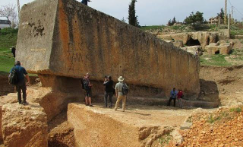
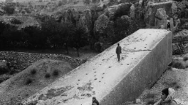
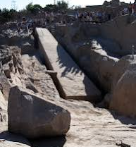
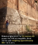
AI – ‘The heaviest megalithic stone block from antiquity is an unnamed, partially buried monolith discovered in the ancient quarry of Baalbek, Lebanon, which weighs an estimated 1,650 tonnes (1,819 US tons). [1, 2]Unearthed in 2014 by a team from the German Archaeological Institute, this massive limestone block measures roughly 19.6 metres long, 6 metres wide, and at least 5.5 metres high. [1, 2, 3]
Top Giant Monoliths of AntiquityThe largest blocks ever carved were all found in the exact same Baalbek limestone quarry. They were intended for the nearby Roman temple complex dedicated to Jupiter but were ultimately abandoned, likely because their immense weight made them impossible to transport. [1, 2]
The Stone of the South: Rediscovered in the 1990s, this massive second monolith weighs an estimated 1,242 tonnes. [1]
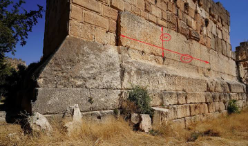
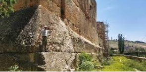
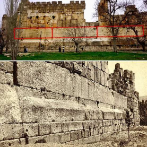
The Stone of the Pregnant Woman: The most famous block on the site, weighing between 1,000 and 1,200 tonnes. It remains partially exposed and has been a tourist attraction for centuries. [1, 2, 3]Heaviest Stones Actually MovedWhile the 1,650-tonne block was never moved out of the quarry, ancient engineers successfully transported other immense blocks nearby. The retaining wall of the Baalbek Temple of Jupiter incorporates the Trilithon, a group of three blocks weighing roughly 800 tonnes each, lifted and fitted seamlessly together.
Ancient builders explicitly designed these giant megalithic structures to withstand devastating earthquakes, but they did not intentionally design them to survive regional floods. Because major cities were built away from predictable deep marine floodplains, seismic activity was their primary engineering enemy. [1]The survival of structures like the 800-tonne Baalbek Trilithon over two millennia is the result of brilliant, deliberate anti-seismic engineering principles. [1, 2]
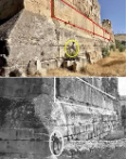
1. The Power of Dry-Stone Masonry (No Mortar)The most profound seismic defence of megalithic walls is that they were built without mortar. When an earthquake strikes a modern concrete or brick wall, the rigid structure resists the energy until it cracks and collapses. [1, 2, 3, 4]By using perfectly carved, dry-stone blocks fitted with millimeter-precision, ancient engineers allowed the stones to shift, slide, and frictionally vibrate against each other. The entire wall essentially behaves as an energy dissipator, absorbing the shockwaves and settling back into its original position under its own massive gravitational weight once the shaking stops. [1, 2]2. Massive Weights as Stabilization AnchorsAt Baalbek, Lebanon—located in the highly active earthquake zone of the Beqaa Valley—the 800-tonne Trilithon stones were placed at the very base of the retaining podium wall. [1, 2]
Low Center of Gravity: Placing the heaviest elements at the foundation created an incredibly stable base.
Resisting Inertia: High-intensity seismic tremors can easily topple small blocks. An 800-tonne block possesses so much mass and inertia that it requires an unfathomable amount of energy to displace, ensuring the temple platform on top remained perfectly level. [1]
3. Shock-Absorbing Joints and ClampsWhile the heaviest monoliths relied purely on gravity, the classical Greco-Roman world heavily employed internal shock-absorbers for columns and multi-block walls: [1, 2]
Lead-Sheathed Metal Ties: Blocks were frequently tied together using “I” or “T”-shaped iron or bronze butterfly clamps. Crucially, the Romans poured molten lead around these metal joints. Lead is a soft, malleable metal that acts like a modern industrial rubber dampener, absorbing seismic energy and protecting the stone from fracturing during a quake. [1, 2]
Segmented Columns: Rather than carving columns out of single pieces of stone (which snap under lateral forces), they used stacked stone “drums” pinned together through the center with dense wooden or metal dowels, allowing the columns to wobble independently without falling down. [1, 2]
Why Floods Weren’t the PriorityWhile Roman civil law heavily prioritized local river flood management (such as building aqueducts, sewers, and deep drainage ditches), their megalithic architecture was rarely designed with catastrophic sea or valley flooding in mind. [1]Megalithic sites like Baalbek, the Parthenon, or the mountain citadels of the Incas were intentionally built on high elevations, natural bedrock platforms, or well-drained hillsides. This geographic positioning naturally protected them from floods, leaving earthquakes as the main environmental hazard to engineer against. [1]
The Incas were masterful engineers who developed some of the most advanced anti-seismic construction methods in human history. Machu Picchu and the imperial city of Cusco are built directly on top of major geological fault lines in Peru, an area plagued by frequent, highly destructive earthquakes.To survive these violent tremors, Inca architects developed a highly sophisticated style of masonry called Ashlar architecture, with inward-leaning walls serving as a primary line of defence.1. Inward-Leaning Walls and TrapezesThe most striking visual element of Inca architecture is the uniform inclination of their walls.
The Inward Lean: Exterior walls do not stand perfectly vertical; they lean inward toward the center of the building at an angle of roughly 3 to 5 degrees. When an earthquake shakes the ground horizontally, this lean pushes the weight of the structure inward, effectively forcing the building to support its own core rather than pulling apart and falling outward.
Trapezoidal Openings: Doors, windows, and interior niches are always shaped like trapezes—wider at the bottom and narrower at the top. This geometric shape distributes the downward weight more evenly and prevents structural stress from cracking the corners of the openings during seismic movements.
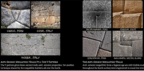
2. Perfect Dry-Stone Interlocking (Ashlar Masonry)Like the Romans at Baalbek, the Incas used absolutely no mortar. Instead, they spent months shaping individual granite blocks using harder river stones, smoothing the edges until they fit together with such precision that a knife blade cannot be slid between them.
Seismic Dancing: Without rigid mortar to snap, the stones can “dance” during an earthquake. They shift, slide, and vibrate independently, absorbing the energy of the tremor.
Self-Centring Design: The stones are carved with slight, hidden concave and convex points on their top and bottom surfaces. When the earthquake ends, the immense weight of the granite naturally guides every block back into its exact original position.
3. L-Shaped Corners and Polygonal BlocksRather than using simple rectangular bricks, Inca masons frequently carved complex, multi-sided stones.
The 12-Angled Stone: Located in Cusco, this famous block locks perfectly into surrounding stones from multiple directions. This polygonal puzzle design means blocks cannot slide out in any single horizontal direction.
L-Shaped Corner Blocks: At the corners of buildings, where structures are most vulnerable to twisting forces, the Incas carved massive “L”-shaped stones out of a single block. This anchored the two intersecting walls together seamlessly, eliminating a weak seam where the walls could separate.
4. Granite Sub-Foundations and TerracesMachu Picchu’s survival is as much about what is underground as what is above.
Deep Bedrock Anchors: Buildings are tied directly into the natural granite bedrock of the mountain ridge using massive stone foundations.
Agricultural Terraces as Retaining Walls: The iconic terraces carving into the hillsides are not just for farming. They act as heavy structural retaining walls that stabilize the steep mountain slopes, preventing the entire citadel from sliding down the mountain due to earthquake-induced landslides or heavy tropical rains.
Beyond Baalbek and South America, sophisticated anti-seismic engineering was independently developed across several major hot zones of antiquity. Ancient civilizations residing along the tectonic boundaries of the Mediterranean and Asia pioneered brilliant methods to manipulate physics, using wood, stone, and metal to neutralize shockwaves. [1, 2, 3, 4]
1. China: Dougong and Composite Earth (500 BC)Ancient Chinese architects created some of the most resilient timber and earthen engineering systems in the world. [1, 2]
Dougong (Interlocking Bracket Sets): Invented around 500 BC, this system uses nested, interlocking wooden brackets without a single nail or glue drop. Under seismic load, the thousands of wooden joints transfer and spread forces flexibly. Scale models have famously withstood simulated earthquakes exceeding magnitude 10.0 without collapsing. [1, 2]
Sticky Rice Mortar and Earthen Fortresses: The massive walls of ancient fortresses and palaces used a composite of earth stabilized with glutinous rice and brown sugar. Combined with internal horizontal bamboo or pine strips, these materials provided tensile strength that allowed rigid walls to flex and even “self-heal” minor cracks over time. [1]
2. Persia: The Oldest Base Isolation (550 BC)The Tomb of Cyrus the Great in modern-day Iran is widely recognized as one of the oldest structurally engineered base-isolation systems in human history. [1, 2]
The Layered Foundation: Built in a highly active seismic zone, the tomb sits on a multi-layered stone foundation. The lower foundation consists of stone bound with sand and lime mortar, topped by a highly polished stone plate that is completely detached from the main tomb structure. [1, 2]
Talc Buffer: A thin layer of talc (soapstone) was placed between the two foundations. When a massive earthquake strikes, the ground and lower foundation shake violently, but the friction is reduced so much that the upper tomb slides gently back and forth, isolated from the destructive energy below. [1, 2]
3. Japan: Shinbashira and Saken (600 AD)Living in the Ring of Fire, Japanese master builders mastered wood mechanics to construct multi-story pagodas that have survived centuries of massive quakes. [1, 2]
The Shinbashira (Central Pendulum): Traditional Japanese pagodas, such as the 7th-century Horyuji Temple, feature a massive central wooden pillar called a shinbashira. This pillar is anchored deep in the ground but is completely disconnected from the floors surrounding it. During an earthquake, each floor sways independently in opposite directions (a snake-dance motion), while the central pillar acts as a heavy internal pendulum dampener, keeping the center of gravity stable.
Saken Framing: This method uses lightweight wooden wall skeletons rather than rigid stone or brick. The frames are coated in wire and traditional plaster, maximizing structural flexibility so walls bend without shattering. [1, 2, 3, 4]
4. Greece and Rome: Anathyrosis and Lead DampenersIn the Mediterranean, the classical world combined precision masonry with metallurgy to counter tremors. [1]
Anathyrosis: Greek engineers carved the contact faces of massive stone blocks so that only the outer edges were perfectly smooth and tightly fitted, while the inner centers were slightly recessed. This prevented the stone cores from grinding against each other and shattering during localized shifting.
Polos and Empolia: The column sections of the Parthenon in Athens were joined inside via a socket system of wooden pegs (polos) fitted into wooden blocks (empolia). Wood absorbs lateral seismic vibrations vastly better than iron or stone, allowing the column drums to wobble and reset.
Lead-Cushioned Iron Clamps: Roman structures like the Colosseum used “I” and “T” shaped metal clamps wrapped in molten lead. The soft lead acted as a shock absorber, protecting the surrounding stone from cracking under tension. [1, 2]’