
AI – ‘Visual art history tools—traditionally used to analyze historic paintings, establish the provenance of stolen masterpieces, or verify architectural blueprints—are increasingly being repurposed to litigate against coercive corporate land grabs. By shifting the “art historical gaze” from canvas to landscapes and data streams, legal teams and human rights researchers can construct definitive evidence of environmental destruction, ancestral displacement, and corporate malpractice.Independent research agencies like Forensic Architecture are pioneering this intersection. Their methodologies demonstrate how art history tools can be effectively deployed within legal arenas: [1, 2]
1. ‘Visual Connoisseurship & Style Analysis applied to Satellite Data’ –
In art history, connoisseurship involves analyzing minute brushstrokes, pigment density, and compositional patterns to authenticate an artwork. [1, 2]
- The Legal Application: This identical methodology is applied to remote sensing and satellite data. Forensic experts utilize spectral band analysis to study variations in light and color across landscapes over time. [1, 2]
- How it Litigates: By evaluating subtle variations in pixels, teams can calculate indices like the Normalized Difference Vegetation Index (NDVI) to track environmental degradation. In court, this functions as irrefutable, empirical proof of illegal corporate logging, toxic dumping, or crop destruction used to pressure indigenous populations off their land. [1, 2]
2. ‘Deep Provenance Research as Land Title Verification’ –
Provenance research tracks the chain of ownership of a piece of art across centuries to expose illicit looting or forced wartime sales. [1, 2]
- The Legal Application: When applied to contested land, provenance tools uncover the historical “chain of custody” of an ecosystem. This involves analyzing colonial maps, tax ledgers, and property deeds alongside local cultural records.
- How it Litigates: Corporations often justify land acquisition through fraudulent or coerced contracts signed by non-representative parties. Art historical provenance methods can unmask these gaps in the timeline, tracing ownership back to original indigenous custody. This effectively undermines corporate claims of “vacant land” (terra nullius) or legitimate purchase in international courts. [1, 2]
3. ‘Photogrammetry & 3D Spatial Reconstruction’ –
Art historians rely on architectural rendering and 3D digital imaging to preserve ruined heritage sites or reconstruct ancient spaces. [1, 2]
- The Legal Application: Using open-source data, localized smartphone footage, and aerial imagery, teams build precise 3D virtual reality models of land conflict zones. [1, 2, 3]
- How it Litigates: If a corporation uses private security forces to demolish a village or build illegal border fences, a 3D reconstruction can recreate the exact timeline of structural violence. These immersive, interactive environments can be submitted as expert testimony in arbitration panels, providing judges with a clear visual perspective of the scene that witness testimony alone cannot capture. [1, 2, 3]
4. ‘Iconographic & Oral History Mapping’ –
Iconography is the branch of art history that deciphers hidden meanings, symbols, and cultural narratives within visual imagery.
- The Legal Application: Many indigenous or marginalized communities do not possess western-style paper land deeds; instead, their land tenure is recorded in community art, oral histories, and landscape markers. “Counter-mapping” projects combine graphic illustration with oral history to map these cultural milestones. [1, 2, 3]
- How it Litigates: By codifying traditional ecological knowledge, artistic maps illustrate exactly how communities have historically used forests, burial grounds, and water systems. When entered into international legal proceedings, these visuals serve as formal evidence of continuous occupation, which is crucial for securing statutory land rights under international human rights frameworks. [1, 2, 3]
Human rights lawyers can utilize “matter in movement” and the historical analysis of architecture to convert physical geography and structural remains into definitive, admissible evidentiary data. Pioneered by research groups like Forensic Architecture, this methodology shifts the focus from abstract legal testimony to the physical environment as an objective witness. [1, 2, 3, 4, 5]By treating architecture as a material reflection of political force, lawyers can visually demonstrate state and corporate complicity before bodies like the International Criminal Court (ICC), the Inter-American Court of Human Rights (IACtHR), and domestic civil tort courtrooms. [1, 2, 3, 4]
1. Proving Forced Displacement via “Matter in Movement”
“Matter in Movement” analyzes how physical substances (soil, debris, dust, smoke, and water) are displaced over time by human intervention. [1, 2]
- The Methodology: Lawyers can cross-reference historic satellite imagery with 3D fluid dynamics or geospatial modeling. Rather than showing a static “before and after” snapshot, this technique models the active mechanics of erasure. It documents the speed and direction of physical demolition debris, weaponized smoke plumes, or deliberate floods. [1, 2]
- Legal Application: In cases of ethnic cleansing or illegal eviction, defendants often claim that communities left voluntarily or due to natural disasters. Proving the velocity, pattern, and thermal signatures of destruction tracks the exact vector of force. This satisfies the legal thresholds for proving mens rea (intent) and actus reus (the act) of forced displacement under Article 7 of the Rome Statute (Crimes Against Humanity). [1, 2]
2. Deconstructing Corporate Enclosure and Land GrabsCorporate land grabs against Indigenous groups frequently rely on legal gray areas, claiming that targeted ancestral lands were “unoccupied,” “barren,” or legally acquired. Historical architectural analysis exposes these claims as false. [1]
- The Methodology: Lawyers use “counter-mapping” and architectural archaeology. They can reconstruct traditional Indigenous dwellings, fence lines, water management systems, and sacred burial sites using remote sensing (LiDAR) and oral histories. Simultaneously, they chart the historical expansion of corporate infrastructure—such as pipelines, private security fencing, and industrialized monoculture roads. [1, 2, 3, 4, 5]
- Legal Application: In transnational civil tort litigation (e.g., suing multinational corporations in their home jurisdictions for overseas abuses), this evidence visualizes the physical enclosure of a community. Showing a timeline of corporate architecture slowly choking out local access to resources proves actionable civil nuisance, trespass, and expropriation of property. It invalidates corporate claims of non-interference by establishing a clear timeline of structural hostility. [1, 2, 3]
3. Exposing Ecocide and Environmental DestructionEnvironmental degradation is rarely an accident; it is the structural byproduct of political and corporate choices. Architectural forensics treats environmental shifts as physical manifestations of structural violence. [1, 2, 3]
- The Methodology: This approach investigates how structural developments change the surrounding material ecosystem. For instance, lawyers can model how a corporate dam altered downstream siltation patterns, how mining waste altered soil chemistry, or how deforestation eroded a specific microclimate. [1, 2]
- Legal Application: In international tribunals, this evidence supports claims of environmental warfare or ecocide. In civil courts, it provides an empirical baseline to quantify damages. By showing how specific corporate architectures directly triggered toxic drift or ecological collapses, plaintiffs establish proximate causation—the most difficult hurdle in environmental tort litigation. [1]
Evidentiary Matrix for CourtroomsTo successfully introduce these concepts into legal proceedings, human rights lawyers structure their presentation using this operational framework:
| Evidentiary Tool [1, 2, 3, 4] | Technical Execution | Legal Application |
|---|---|---|
| Volumetric 3D Modeling | Reconstructing destroyed settlements using crowdsourced smartphone data, satellite imagery, and witness testimony. | Re-establishes the physical reality of a community erased by a land grab. |
| Material Continuity Trajectories | Tracking the physical relocation of building materials or topsoil over decades. | Refutes claims that lands were historically “vacant” or naturally degraded. |
| Spatial Inverted Chronologies | Playing architectural changes in reverse via interactive timelines. | Pinpoints the exact timestamp and responsible entity for an illegal corporate enclosure. |
If you are building a specific legal strategy, tell me:
- What is the target jurisdiction or tribunal? (e.g., ICC, domestic civil court, regional human rights court).
- What specific type of data is available? (e.g., satellite archives, witness testimony, corporate building plans).
- Who is the primary adversary? (e.g., a state military, a multinational mining company). [1]
I can provide tailored advice on structuring the admissibility arguments for your digital spatial evidence. [1, 2]
Human rights lawyers are increasingly using art history tools and visual methodologies to protect Indigenous land from corporate grabs. Traditional Western legal systems usually favor written deeds, leaving Indigenous communities with a high “burden of proof” when defending ancestral land that relies on oral or visual histories. [1, 2, 3]By partnering with research agencies like Forensic Architecture, lawyers bridge this gap. They translate historical art, architectural memory, and visual documentation into legally binding evidence. [1, 2, 3]
1. Visual Analysis of Historical Maps and ArtArt history tools like iconography (interpreting symbols in images) and provenance research (tracing an object’s history and ownership) help lawyers verify territorial boundaries. [1, 2, 3]
- Reading Landscapes: Lawyers use formal visual analysis to decode colonial-era sketches, paintings, and cartography. This reveals geographic markers that confirm long-term Indigenous occupation. [1]
- Proving Continuous Stewardship: Art historians trace the history of regional artistic materials (e.g., specific pigments or textiles). This acts as physical evidence of historical trade, resources, and land use in court.
2. Forensic Spatial Modeling and ReconstructionHuman rights groups treat the physical land as an archive. They use architectural and art history techniques to document corporate ecocide and displacement. [1, 2]
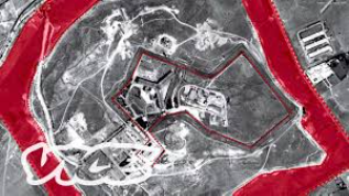
- 3D Virtual Heritage: Agencies use digital modeling to reconstruct traditional environments destroyed by corporate activities. An example is Forensic Architecture’s reconstruction of Namibian grasslands to prove the long-term impact of colonial and corporate landscape alteration. [1, 2, 3]
- Material Forensics: Analyzing shrapnel marks, soil changes, or structural damage on sacred buildings turns architectural surfaces into photographic evidence of violence. This allows lawyers to visually demonstrate corporate or state-sponsored property destruction. [1, 2]
3. Overcoming Western “Burden of Proof” via Legal Aesthetics [1]Most human rights courts dismiss oral histories or traditional songs as valid evidence. Art history methodologies create a “counter-forensics” framework that changes how courts see evidence. [1, 2, 3]
- Translating Intangible Heritage: Lawyers use visual aesthetics to present traditional knowledge in ways Western courts accept. They combine historical artwork with satellite images and mapping data. [1, 2, 3]
- Proving Cultural Value: Showing how a piece of land connects to cultural artifacts—like ceremonial masks or sacred art—helps lawyers build a stronger case. It shifts the legal perspective from viewing land as a commodity to protecting it as cultural heritage. [1, 2, 3, 4]
4. Public Advocacy and “Museum as Courtroom”Art history practices rely on public exhibition. Human rights lawyers use this to bring local land grab cases to global attention. [1, 2]
- Exhibiting Evidence: Legal teams often display their 3D models and visual timelines in major cultural institutions. This creates public pressure that courts and corporations cannot ignore. [1, 2, 3]
- Public Tribunals: Staging detailed visual exhibitions acts as a “people’s court.” This helps communities control their own narrative when local legal systems fail them. [1, 2]
Art history and visual tools offer human rights lawyers innovative evidentiary methodologies to secure civil and international law remedies for communities fighting corporate land grabs. By shifting the legal gaze from abstract land titles to physical, historical, and environmental reality, these tools unearth corporate and state abuses. [1]The specific visual tools, their art-historical foundations, and the corresponding legal remedies include:1. Spatial Analysis and Forensic Architecture [1, 2]Human rights lawyers use architectural 3D modeling, fluid dynamics, and spatial analysis to reconstruct contested environments over time. Pioneered by research agencies like Forensic Architecture, these methods turn geography into an active archive of state and corporate violence. [1, 2, 3, 4]
- Art History Foundation: This relies on the concept of “matter in movement” and the historical analysis of architecture as a reflection of political force. It utilizes photogrammetry—extracting 3D data from historical photographs and perspective artwork—to trace altered landscapes. [1, 2]
- Legal Remedy: Lawyers introduce these models into civil tort litigation (for property destruction or corporate negligence) and before the International Criminal Court (ICC) or regional bodies like the Inter-American Court of Human Rights. They serve as definitive evidence to prove forced displacement, physical corporate enclosure, or environmental destruction. [1, 2, 3, 4]
Watch how multidisciplinary experts use architectural tools and multimedia to build admissible visual evidence of human rights violations:
4mMeet The Team Investigating Human Rights Violations …VICEYouTube · 8 Aug 20172. Counter-Cartography and Satellite ArchaeologyCorporate land grabs often rely on official, Eurocentric geometric maps that render indigenous and local communities invisible. Lawyers counter this using satellite archaeology, hyper-spectral imaging, and community-led counter-mapping. [1, 2, 3, 4]
- Art History Foundation: This draws directly from Critical Cartography, an art-historical critique of the geometric map as an instrument of imperial conquest and land commodification. By interpreting subtle shadows and botanical anomalies in historical aerial footage, researchers reveal erased villages, ancestral burial grounds, and historic irrigation systems. [1, 2, 3, 4]
- Legal Remedy: These visual assets are weaponised under international human rights treaties (such as the UN Declaration on the Rights of Indigenous Peoples) to enforce the right to Free, Prior, and Informed Consent (FPIC). They provide the empirical proof required to establish ancestral title, challenging corporate claims that the land was historically vacant or “unarable”. [1, 2, 3]
3. Cultural Heritage, Provenance, and Moral RightsWhen corporations seize lands, they often destroy or misappropriate local cultural property, sacred sites, and artifacts. Lawyers use provenance tracking, architectural heritage mapping, and database archiving. [1, 2, 3, 4]
- Art History Foundation: This relies on provenance research and cultural property history, methodologies originally perfected to track Nazi-looted art or colonial antiquities. It also utilizes Art Loss databases to establish a continuous historical chain of community custody. [1, 2, 3, 4, 5]
- Legal Remedy: Under international cultural heritage law (such as the UNESCO 1970 Convention) and the Berne Convention’s Moral Rights (Right to Integrity), lawyers can sue corporations for the destruction or theft of communal cultural assets. Proving the destruction of art and sacred infrastructure can escalate a civil property dispute into an international claim for reparations and cultural restitution. [1, 2, 3, 4, 5]
Summary of Legal Fora and Remedies
| Visual/Art Tool [1, 2, 3, 4, 5, 6, 7, 8, 9, 10] | Primary Methodology | Target Legal Remedy |
|---|---|---|
| Forensic Architecture | 3D Environmental Modelling | Civil Tort Damage Suits / ICC Evidentiary Submissions |
| Counter-Cartography | Satellite Archaeology & Smudge Analysis | Ancestral Land Title Claims / FPIC Violations |
| Provenance Tracking | Cultural Heritage Archiving & Mapping | International Restitution & Reparation Claims. |
In the English High Court a Barrister cannot directly submit arguments or evidence treating architecture as a “material reflection of political force” to demonstrate complicity. The Civil Procedure Rules (CPR) strictly govern the English High Court and require evidence to be objective, factual, and directly causative of the pleaded civil tort (such as negligence, nuisance, or conspiracy). Rhetorical, ideological, or highly theoretical assertions regarding political structures are routinely struck out as irrelevant or vexatious under CPR Part 3.4. [1, 2, 3]
However, a Barrister can achieve a similar practical outcome by restructuring this concept into admissible, scientifically rigorous spatial and digital forensics (often called “forensic architecture”). [1]To visually demonstrate state or corporate complicity within the strict confines of the CPR, the legal team must filter these concepts through the following procedural mechanisms:1. Reframe Rhetoric into Expert Evidence (CPR Part 35)The court will completely reject a barrister’s own political interpretation of a building. Instead, the data must be introduced via an independent expert witness report under CPR Part 35.
- The Threshold: To be admissible, the expert evidence must provide necessary, objective technical analysis that falls outside the judge’s knowledge. [1]
- The Method: An expert (such as a structural engineer, surveyor, or digital forensic analyst) can present spatial reconstructions, 3D fluid dynamics, or data mapping. [1]
- The Target: The expert cannot use the platform to argue “political force.” They must strictly prove material facts, such as how corporate design choices directly caused physical harm or how state-controlled infrastructure intentionally restricted access (proving elements of the tort). [1, 2]
2. Admissibility of Visual and Digital Evidence (CPR Part 32)Visual models, animations, and interactive maps are highly effective in court, but they are categorized as demonstrative or documentary evidence under CPR Part 32.
- Source Validation: Every pixel of a 3D architectural model or video reconstruction must be tethered to verifiable, disclosed data (e.g., satellite imagery, LiDAR scans, or internal corporate CAD files). [1, 2]
- The Prohibition of Bias: If a visual model includes political commentary, dramatic lighting, or unsubstantiated animations, the opposing council will successfully argue to exclude it because it is unfairly prejudicial or lacks an objective foundation.
3. Evidencing Complicity via Disclosure (CPR Part 57AD / Part 31)To link the physical architecture to state or corporate complicity, a barrister must rely on the “paper trail” behind the construction. [1]
- Intent and Knowledge: Under the applicable disclosure models, the barrister must seek internal emails, cabinet minutes, or board resolutions. [1]
- The Connection: The visual evidence is then used to show that the defendants knew the physical layout would cause harm, but built it anyway to prioritize corporate profit or state control. The architecture acts as the physical manifestation of the breach, while the documents prove the complicity. [1]
Summary of the Legal Translation
| Radical/Theoretical Concept [1, 2, 3] | Admissible CPR Equivalent |
|---|---|
| “Architecture as political force” | Proving breach of duty or intentional harm via structural design. |
| “Visual demonstration of complicity” | Verifiable 3D spatial reconstructions linked to internal corporate/state disclosure documents. |
| “Barrister’s ideological analysis” | Independent Expert Witness Evidence under CPR Part 35. |